Table of Contents
ToggleOverview
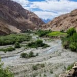
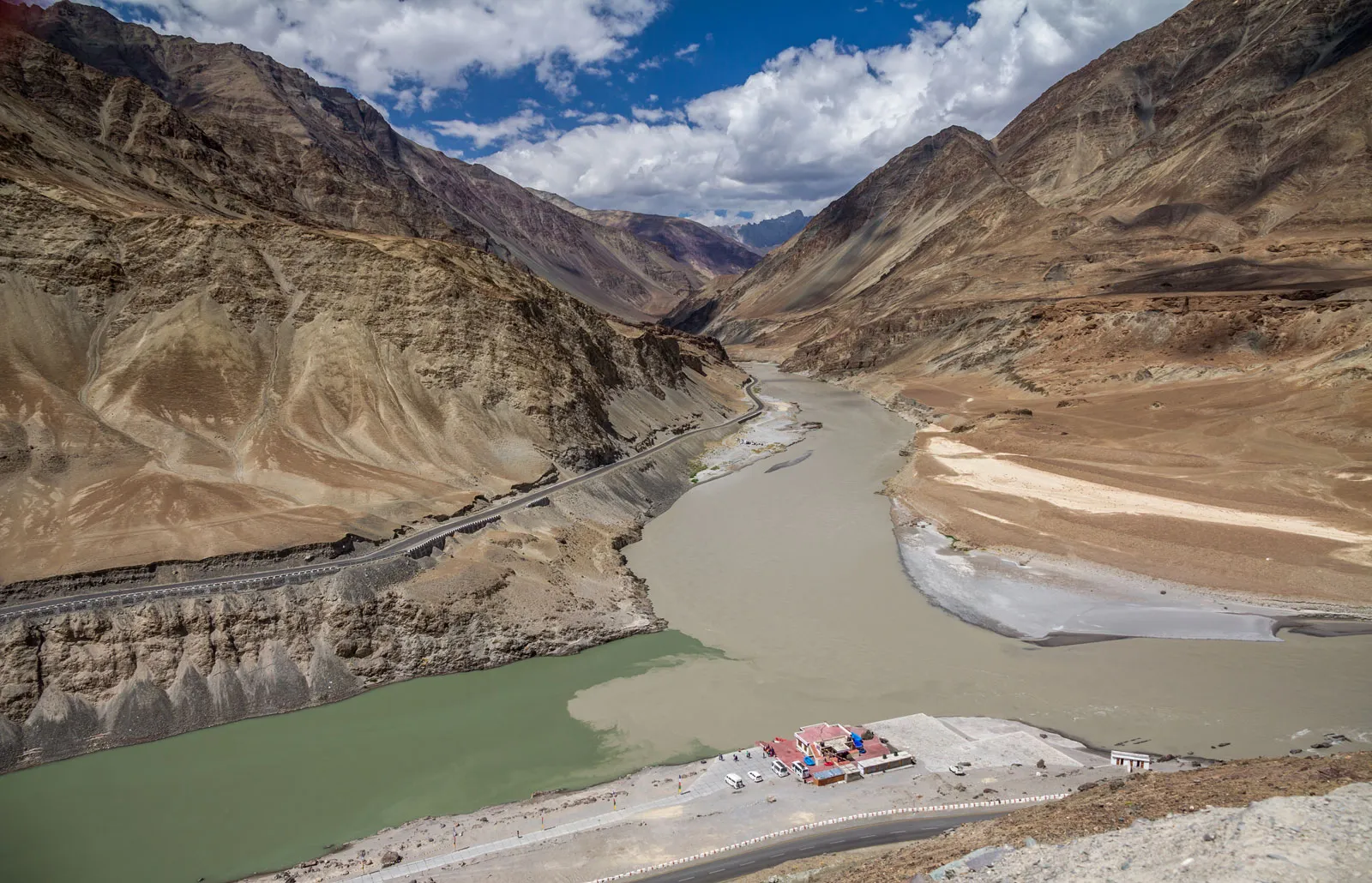
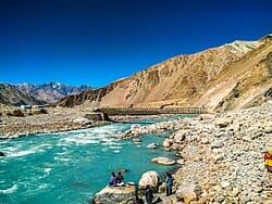
Situated between Karakoram and Himalayas’ towering ranges, Ladakh is also famous not only for its barren desert vistas and Buddhist monasteries but for a network of some of the world’s highest motorable passes in Ladakh. From dizzying elevations at Khardung La to boulder-studded hills at Tanglang La, these high-altitude road passes are the lifeline that binds remote villages, sacred places, and strategic military strongholds. For travel adventure seekers on their way for a Ladakh road trip, having the know-how of every pass’s uniqueness—altitude, topography, history, and season’s hardships—is part and parcel. Within this detailed traveling guide, we unlock all information you must have regarding Ladakh’s essential must-visit passes, including expert advice, safe driving tips, and insider intel to make your trip memorable.

Why Ladakh's High-Altitude Passes Are the Heartbeat of Adventure Tourism in Ladakh
Every year, thousands of travelers flock to Leh and beyond, attracted by the promise of challenging adventure over Leh-Manali highway passes, Srinagar-Leh highway, and off-the-beaten-path loops. These mountain roads traverse some of the highest motorable terrain in the world, offering:
- Breathtaking View: Blazing sun-baked valleys give way to snow-covered peaks and broad sweeps of panorama at every hairpin bend.
- Cultural Crossroads: Ancient trade routes linking Tibet, Kashgar, and the Indian plains resonate in remote villages located near Zoji La and Fotu La.
- Thrill-packed Rides: For bikers, traveling the Khardung La ascent or overcoming Chang La’s snow-covered slopes is the ultimate rush of adrenaline.
- Strategic Significance: The majority of passes, such as Zoji La pass, are of deep military importance, safeguarding ancient caravan trails.
By weaving the lofty heights of Chang La, Tanglang La, and beyond into your Ladakh travel itinerary, you’ll experience the true spirit of this “Land of High Passes.”
The Major Mountain Passes of Ladakh: Altitudes, Routes, and Highlights
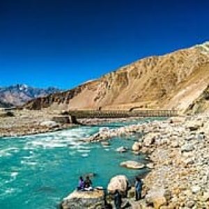
Khardung La (5,359 m): The Gateway to Nubra Valley
Often touted as the world’s highest motorable pass, Khardung La commands an ascent from Leh at 3,500 m through a series of switchbacks that test both driver and machine. Once atop, you’re rewarded with panoramic views of the Nubra and Shyok river valleys. Key facts:
- Altitude: 5,359 m (17,582 ft)
- Road Type: Gravel and compacted earth; prone to snowdrifts in winter
- Highlights: border outpost signboards, local tea stalls, camel caravan views of the “cold desert” of Hunder
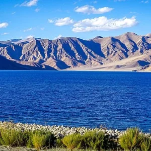
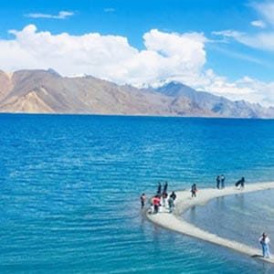
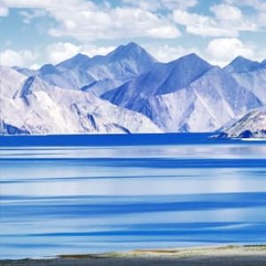
Chang La (5,360 m): The Silver Pass on the Pangong Circuit
Connecting Leh to the surreal turquoise waters of Pangong Tso, Chang La remains a hair’s breadth above Khardung La but totally different in mood. Leh road passes over the Tangtse stream and meanders past shrines constructed by nomadic families.
- Altitude: 5,360 m (17,590 ft)
- Road Conditions: Paved but narrow; frequent landslides during premonsoon
- Highlights: Ancient stupas, yak-grazed meadows, and rolling views of Pangong’s mirror-horizon
Tanglang La (5,328 m): A Photographer’s Heaven on the Manali-Leh Highway
Tanglang La’s gradual, long ascent makes it a motorcyclist’s and road-tripper’s delight. On top of the pass, a line of prayer flags waves against endless blue.
- Altitude: 5,328 m (17,480 ft)
- Terrain: Well-maintained tarmac with occasional potholes; watch out for surprise snow patches
- Highlights: Prayer flag sites, ridgeline vistas, and included on the world’s highest drive roads
Fotu La (4,108 m): The Deterrent Divide along the Kargil–Leh Highway
On the ancient Srinagar–Leh road, Fotu La divides the productive Suru Valley from the barren land on its approach to Lamayuru. It is too frequently overshadowed by more highly remarked neighbors but repays with singular vistas of jagged rock formations.
- Altitude: 4,108 m (13,477 ft)
- Road Surface: Gravel-asphalt mix; construction works can cause holdups
- Highlights: Panoramic viewpoints surrounding the Suru Valley, tea stops in the open air, occasional sightings of Himalayan ibex
Zoji La (3,528 m): The Treacherous Pass to Kargil
Zoji La is the only entry point between Srinagar and Leh during most of the year and offers significant challenges, from winter avalanches to summer landslides.
- Altitude: 3,528 m (11,575 ft)
- Road Hazards: Narrow gorges, avalanche-slope risks, and frequent military convoys
- Highlights: Tibetan plateaus beyond the pass, multi-ethnic trade bazaars at Sonamarg
Insider’s Note: Less-popular passes like Namika La (3,700 m) and Baralacha La (4,890 m) on the Manali-Leh highway are perfect for those seeking isolation from the crowd.
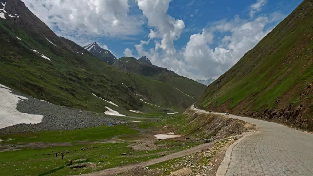
Best Time to Cross Ladakh's Passes: Seasonal Windows & Road Conditions
Ladakh high-altitude roads are carved through some of the harshest conditions on earth. Familiarity with seasonal patterns is essential for a hassle-free and Ladakh passes safe expedition:
Summer (Mid-May to Early September)
- All major passes (Khardung La, Chang La, Tanglang La) are open; occasional showers can lead to landslides.
- Day temperatures range from 5 °C at highest passes to 25 °C in lower valleys.
- Peak tourist season for motorcycle tours in Ladakh and guided jeep safaris.
Pre-Monsoon (Late April to Mid-May)
- Lower traffic volumes; roads are still snow-clearing.
- Dangers of fresh snow and icy stretches—take studded tires or chains.
- Permit checkpoints start opening at Zoji La and the Nubra sector.
Autumn (September to Mid-October)
- Chilly, clear weather and golden chinar leaves provide great photography.
- Limited road maintenance—potholes and debris might pile up.
- Some pass-to-pass mini-circuits (e.g., Leh → Khardung La → Pangong → Chang La → Leh) can be accomplished in 3–4 days.
Winter (November to March)
- Zoji La only is sometimes open and strictly under military convoy.
- The rest are closed under deep snow; high-ground expeditions require snowmobiles or special mountaineering gears.
- Best time to plan next year’s high-altitude road trip Ladakh but not actually travel.
Road Trip Planning and Permits: Dealing with Checkpoints and Legislation
Passing through multiple passes in Ladakh requires pre-planning regarding permit regimes and convoy schedules:
Inner Line Permits (ILP)
Required by all foreign tourists and Indian nationals traveling beyond Leh to Nubra, Pangong, or Chushul.
Issued at Leh’s DC Office; it takes 1–2 days—carry passport-sized photographs and vehicle papers.
Srinagar–Leh Highway Convoys
Zoji La convoy schedules are time-dependent; check with BRO before arrival.
Convoy from Sonamarg is unpredictable; not permitted at night.
Vehicle Rules
Maximum of five passengers for each motorcycling group; off-road motorcycle travel typically requires a special permit.
Rental cars should be SUVs of high clearance; most rental operators restrict traveling past some passes.
Fuel Refills
Petrol pumps at Leh and Kargil are reliable; fill up in Leh before heading north to Nubra or east to Pangong.
Take at least one spare jerry can; remote tea stalls occasionally carry fuel at a premium.
Pro Tip: Always keep photocopies of permits and vehicle RCs in a waterproof folder handy.
Altitude Sickness Prevention: Staying Healthy Above 3,000 Meters
Any trip with Khardung La, Chang La, or Tanglang La must consider the risks of acute mountain sickness (AMS):
Gradual Acclimatization
- Spend a minimum of two nights in Leh (3,500 m) prior to reaching higher elevations.
- Make day trips to Shanti Stupa (3,600 m) or Magnetic Hill (4,000 m) rather than climbing directly to 5,000 m.
Hydration & Diet
- Drink 4–5 liters of water per day; avoid alcohol and heavy meals on travel days.
- Include iron-rich foods (peas, spinach) and local soups such as thukpa.
Medication
- Talk to a doctor regarding Diamox (Acetazolamide)—begin 24 hours prior to ascent.
- Bring painkillers, anti-nausea tablets, and a portable pulse oximeter.
Rest & Monitoring
- Limit physical exertion for the first 24 hours at a new altitude.
- Recognize early symptoms: headache, nausea, dizziness. Descend immediately if severe.
- By respecting your body’s limits and following acclimatization protocols, you’ll tackle the highest passes in Ladakh safely and confidently.
Packing Checklist for Ladakh High-altitude Passes
Traveling through several road passes requires adventure equipment as well as health-safety supplies:
Clothing Layers
- Moisture-wicking base layers, fleece jacket, down jacket, wind-proof shell
- Thermal gloves, woollen hat, gaiters to cover snow’dust
Footwear
- Waterproof boots with ankle support
- Good straps or crampons if you intend to get down at the highest passes
Vehicle Accessories
- Tubeless puncture repair kit for tyres, spare inner tubes, high performance brake oil
- Portable compressor, tyre deflator, extra clutch and brake wires for cycles
Health & Safety
- Complete first-aid kit, blister pads, antiseptics, medication for high altitude
- Hand-sanitizer, refillable water bottle with in-built filter, water purification tablets
Navigation & Communication
- Offline maps on GPS enabled smartphone, physical topo maps for Leh Manali highway
- Remote sections require satellite phone rental; two way radios if driving in convoy
Camping & Comfort
- Lightweight tent rated –10 °C, sleeping bag rated –20 °C, insulated sleeping mat
- Portable stove, high calorietrail mix, instant soups, tea leaves
- Pack sensibly to be well prepared for surprise weather changes and road side breakdowns while traversing Ladakh’s fabled high altitude passes.
Accommodation Options Along the Pass Circuit
Though Leh remains the primary basecamp, wisely placed stops and campsites can improve your pass-crossing itinerary:
Leh Town
- Large range of guesthouses, luxury tented camps, and homestays. Best for acclimatization days.
- Local cuisine (thukpa, momos) and gear shopping (rental bikes, down jackets).
Nubra Valley (Hunder / Diskit)
- Desert camps near Khardung La exit, with Bactrian camel treks.
- Eco-camps run by communities offering traditional Ladakhi food.
Pangong Tso Camps
- Tents in lakeside camps at Spangmik or Marsimik, a short drive from Chang La. Rise to sunrise reflections on the lake.
Suru Valley (Kargil / Sankoo)
- Homestays and budget hotels at Fotu La. Ideal for dividing the Srinagar–Leh sector.
En Route Stops on Manali-Leh
- Jispa and Sarchu camps; permit stops are done in these sectors—incorporate additional buffer time.
- Advance booking, especially for summer seasons, streamlines logistics on your Ladakh passes adventure.
Photography and Adventure in Ladakh Passes
With each go offering breathtaking juxtaposition of rock, snow, and sky, this is the way to mark out your adventure:
Golden Hour at the Summit Pass
- Find yourself at dawn at Khardung La to capture milkay astrophotography and pastel-colored sky.
- Sun down over Chang La glints upon the snowy flank—experiment taking a wide angle lens to make huge sweeps across skies.
Polarizing Filters
- Dark blue skies and minimize glare on the snowfields of Tanglang La.
Action Images for Riders
- Set a helmet cam for POV shots at the hairpin turns of Zoji La.
- Stop bikers on loose gravel on Chang La’s downhill with burst mode.
Local Portraits
- Obtain permission to photograph nomadic shepherds or border-road laborers bundled against the wind.
Safety First: Most Crucial Safety Measures for Overcoming Ladakh's Passes
- Check Daily Weather Forecasts: Blizzards or landslides can shut down passes at short notice—stay informed through local BRO notifications.
- Respect Convoy Discipline on Zoji La: Stray off marked lanes at your own risk; military escorts protect against avalanches.
- Keep Vehicle in Good Health: Have a full service check prior to departure—brakes, clutch, and cooling system essential at high altitudes.
- Buddy System: Never tackle remote passes by yourself. Always travel in twos or threes, equipped with satellite communication sets.
- Copy Emergency Contacts: Share your itinerary with family or guesthouse hosts in Leh; include BRO and local ambulance numbers.
By embedding these precautions into your adventure, you’ll ensure that the thrilling experience of high-altitude passes in Ladakh remains safe and memorable.
Conclusion: Embrace the Majesty of Ladakh’s Legendary Passes
From the wind-swept peaks of Khardung La to the serene shores of Pangong Tso beyond Chang La, Ladakh’s passes are not merely highways—they’re doorways to a realm of excessive beauty and cross-cultural intersections. Whether you’re a seasoned motorcyclist craving the ultimate motorbike tour in Ladakh, a photographer chasing the perfect alpine glow, or a traveler seeking solitude above 5,000 meters, mastering these passes is the key to unlocking Ladakh’s soul. Armed with this comprehensive guide—complete with seasonal advice, permit details, packing checklists, and safety protocols—you’re ready to embark on a life changing high altitude odyssey across the iconic passes in Ladakh. Travel light, ascend high, and let the mountains speak a tale of you.
How to book Ladakh tour online?
Contact Brown Chinar at +91 6005039532/+91 9906188874 or Email us at : Enquiry@brownchinarkashmir.com
People Also Ask
What are the highest motorable passes in Ladakh?
Ladakh is home to some of the world’s tallest drivable roads, including Khardung La (5,359 m), Chang La (5,360 m), and Tanglang La (5,328 m). These high altitude passes in Ladakh draw adventure seekers and motorbike enthusiasts from around the globe.
How do I prepare for the altitude at Khardung La?
Spend at least two nights acclimatizing in Leh (3,500 m), stay hydrated, eat light meals, and consider taking Diamox (acetazolamide) 24 hours before tackling this iconic Ladakh pass.
When is the best time to drive the Srinagar–Leh highway via Zoji La?
The optimal window for the Srinagar–Leh highway—including the strategic Zoji La pass—is mid May to early October, when snow clearance is complete and roads are relatively safe from avalanches.
Are permits required to cross Nubra Valley via Khardung La?
Yes. Indian nationals need an Inner Line Permit (ILP) to travel beyond Leh to Nubra Valley; foreigners must obtain a Protected Area Permit (PAP), both issued at the DC office in Leh.
What type of vehicle is best for the Leh–Manali highway passes?
A high clearance SUV or a well maintained adventure motorcycle is ideal for tackling Manali–Leh passes like Bara Lacha La (4,890 m) and Rohtang La (3,979 m), thanks to their rugged terrain.
How long does it take to ride from Leh to Nubra Valley via Khardung La?
The 120 km journey from Leh to Nubra Valley typically takes 4–6 hours, depending on weather and road conditions across this famous Ladakh pass.
What safety gear is essential for biking across Chang La?
Riders should carry insulated riding gear, crash proof helmet, knee and elbow guards, and a windproof jacket to navigate Chang La’s icy winds and sudden temperature drops.
Can I visit Pangong Tso via Chang La in a single day from Leh?
Yes, a well planned day trip covers the 160 km round trip via Chang La, but expect 7–9 hours of driving; leave early and factor in acclimatization breaks at the pass.
What are the road conditions like on Tanglang La?
Tanglang La on the Manali–Leh highway features mostly paved stretches with occasional potholes; rain or pre monsoon landslides can cause temporary closures.
Is fuel available en route to Khardung La?
Fuel stations exist in Leh and Diskit (Nubra Valley), but none between—always top up in Leh and carry an extra jerry can when exploring these remote Ladakh passes.
What wildlife might I spot along Fotu La on the Kargil–Leh route?
The Fotu La pass (4,108 m) area is known for Himalayan ibex and marmots; early morning sightings are common, especially near rocky outcrops.
How do I plan a circuit covering Khardung La, Chang La, and Tanglang La?
A 5–7 day itinerary from Leh can loop through Nubra via Khardung La, then Pangong via Chang La, returning via Tanglang La—allowing proper acclimatization and sightseeing.
Are there organized jeep tours for the high altitude passes in Ladakh?
Yes—local operators offer multi day jeep safaris covering key passes like Chang La, Tanglang La, and Baralacha La, with camping options under the stars.
What medical facilities are available near Zoji La?
Medical aid posts and DEC (Defense Expeditionary Clinic) tents at Sonamarg and the Zoji La pass support emergency care, but serious cases require evacuation to Srinagar.
How do landslides affect travel on the Srinagar–Leh highway?
Monsoon-triggered landslides around Zoji La and Fotu La can close roads for hours or days; always check BRO (Border Roads Organisation) updates before departure.
Is it safe to drive after sunset on Ladakh passes?
Night driving is discouraged due to unlit stretches, wildlife crossings, and sudden weather changes; plan all pass crossings during daylight hours.
What cultural experiences can be combined with pass crossings?
Near Khardung La, visit Diskit Monastery; en route to Chang La, explore Tso Morriri Lake; and on the Manali–Leh route, stop at Key Monastery for a taste of Ladakhi heritage.
How do I maintain my motorcycle for high altitude passes?
Ensure your bike’s air filter is clean, use high altitude jetting, carry extra clutch and brake cables, and perform a full service in Leh before heading to the passes.
What are some lesser known passes to explore in Ladakh?
Namika La (3,700 m) between Zanskar and Sham Valley, and Baralacha La (4,890 m) on the Manali–Leh road, offer solitude and offbeat vistas away from busy routes.
Can solo female travelers safely navigate Ladakh passes?
Yes, with proper planning—join group tours, hire licensed local drivers, and book homestays or camps in advance to ensure support along remote passes.
What smartphone apps help with navigation on Ladakh passes?
Offline GPS apps like Maps.me and ViewRanger work well in areas with no network; always download route maps beforehand for Khardung La and Chang La.
How do I avoid altitude sickness on a Manali–Leh passes tour?
Start with short day rides to Rohtang La, rest in Keylong, and spend a night in Sarchu (4,200 m) before pushing to Taglang La and Leh for gradual acclimatization.
Are local SIM cards useful for pass crossing connectivity?
Jio and Airtel offer intermittent 4G coverage up to Leh and parts of the Manali–Leh highway, but network drops frequently; rely on satellite comms for full coverage.
What permits are needed for biking across Baralacha La?
An ILP covers travel along the Manali–Leh route, including Baralacha La; no separate permit is required but vehicle papers and tickets must be carried at all checkpoints.
How can I capture the best photos of Ladakh’s mountain passes?
Plan for sunrise at Khardung La, use a polarizing filter to deepen skies at Chang La, and frame prayer flags against Tanglang La’s ridgelines to create striking high altitude pass imagery.