Table of Contents
ToggleOverview
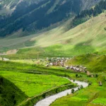
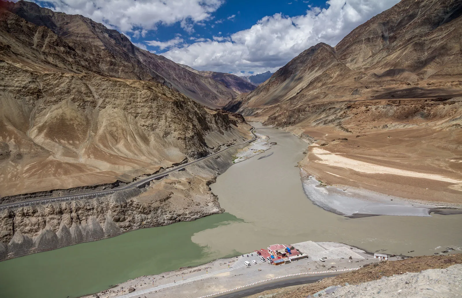
Starting the Kashmir Great Lakes Trek alone sets off a transforming trip across some of the most unspoiled and dramatic Himalayan scenery. For daring backpackers, this walk ranks among the best Kashmir hiking paths winding through alpine meadows, high-altitude lakes, and jagged peaks. Perfect for anyone looking to really connect with nature and challenge personal boundaries, solo trekking in Kashmir provides a rare combination of peace, self-reliance, and raw natural beauty.

Why Choose the Great Lakes Trek in Kashmir?
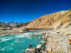
Within a rather small 70–80 km circuit, the Great Lakes walk in Kashmir stands out for its amazing range of landscape. Before arriving at crystalline lakes including Vishansar, Krishansar, and Gadsar, you will walk across rich woodland, meadows full of wildflowers, and moraines. This path provides solitude, wildlife sightings (marmots, ibex, even bears), and unbroken views of snow-capped mountains for solo trekkers yearning an immersive wilderness experience. Unlike more well-known treks in Nepal or Uttarakhand, the Kashmir Great Lakes Trek stays rather empty, allowing you to walk at your own speed.
Traveling Alone: Accepting the Adventure
Trekking carries special benefits as well as obligations. Choosing a Kashmir Great Lakes trek solo helps you develop mindfulness, confidence, and decision-making ability. Early mornings in far-off campsite become times of great silence; evenings provide continuous stargazing above Himalayan summits. Successful solo trekking in Kashmir depends on careful planning, extensive research, honest assessment of your fitness and experience. Create a flexible schedule, pack carefully, and let reliable friends know about your daily itinerary.
Perfect Time for Trekking Kashmir Great Lakes
Your Great Lakes walk difficulty and general enjoyment depend much on seasons. Trekking the Kashmir Great Lakes is best done midneys in June through early September:
June–July: wildflowers blossom in alpine meadows; snow patches linger above 4,000 m.
August: Stable weather; lakes have completely thawed; occasional afternoon showers.
Early September: Less trail users; clear sky and cooler evenings.
Outside this window, snow or subject to strong altitude storms could block trails, so increasing both risk and effort.
Laws and Approaches
Get the necessary Kashmir trekking permits before leaving:
- Checkpost Permit issued by the Forest Department in Sonamarg (allow 30–60 minutes)
- For tracking and safety, single hikers must register at the Sonamarg police station.
- Bring several photocopies of your emergency contact, ID, and permit. Check current rules at the Srinagar or Sonamarg permit offices; seasonally, fees and procedures vary.
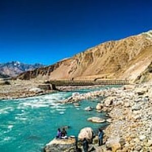
Making It There: Srinagar to Sonamarg
Your adventure starts in the summer capital of Kashmir, Srinagar.
By Road: Sonamarg is 80 km northeast of Srinagar on NH1D, a picturesque 2-3 hour drive. From Lal Chowk daily shared taxis and local buses leave.
By Taxi: For ₹2,000–2,500 onefty-way, arrange a private taxi or share with other trekkers.
Before entering the wild, stock Sonamarg’s small market with snacks, water purification tablets, and any last-minute gear.
Comprehensive Schedule for Solo Trekkers
A common 8 day plan:
Day | Route | Distance | Camp Site | |
1 | Sonamarg → Nichnai Pass → Nichnai Nullah | 12 km | Nichnai Nullah Valley | |
2 | Nichnai → Vishansar Lake | 10 km | Near Vishansar Lake | |
3 | Vishansar Lake → Krishansar Lake → Gadsar | 15 km | Gadsar Lake Shore | |
4 | Gadsar → Satsar Lakes → Gadsar Pass | 12 km | Satsar Meadows | |
5 | Satsar → Gangabal Lake | 10 km | Gangabal Campsite | |
6 | Gangabal → Naranag via Mulsar Pass | 14 km | Mulsar Meadows | |
7 | Naranag → Sonamarg (taxi/bus back to Srinagar) | 20 km | — |
This plan allows you time to enjoy every lake and meadow by balancing daily distances (8–15 km) with acclimatization. Flexibility is important; weather or personal pace may call for including an acclimatization rest day close to Vishansar.
Parks and Landforms: Highlights of the Route
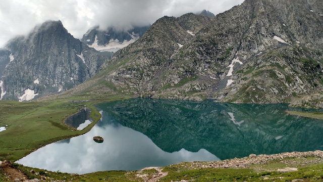
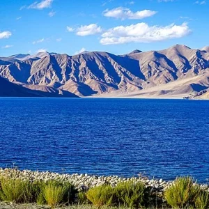
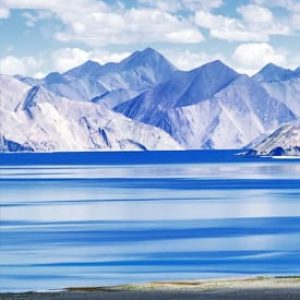
- Ideal for first-time camp reflections, Vishansar Lake (4,200 m) is horseshoe-shaped sapphire lake surrounded by rich grasslands.
- Slightly smaller, noted for trout and Tibetan traders’ summer camps, Krishansar Lake (4,101 m).
- Rising among scree slopes and home to elusive Himalayan marmots, Gadsar Lake (4,300 m) is the highest lake on the road.
- Comprising seven twin lakes tucked in a high alpine bowl, Satsar Lakes (4,200 m) each reflect a different shade of blue.
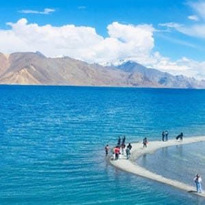
- The last lake close to Harmukh Peak, Gangabal Lake (3,570 m), is brilliant with wildflowers and a view of snow-capped mountains.
These highlights best capture the reasons the Kashmir Great Lakes walk is praised for exceptional biodiversity, peaceful camping areas, and raw wilderness beauty.
Degree of difficulty and fitness requirements
The Great Lakes walk difficulty is classified as moderate to demanding:
Peaks of 4,300 m call for acclimation and awareness of altitude illness.
Terrain tests endurance and balance: glacial moraines, river crossings, and steep ascents and descents.
Daily treks range from 10 to 15 kilometers with sporadic 800 to 1,200 m elevation change.
Prepare by at least 8–10 weeks of cardiovascular exercise (hiking, cycling, jogging) and practice multi day camping to replicate carrying a laden pack.
Packing List and Basic Tools
A soloer’s comfort and safety depend on a well-planned packing list for the Great Lakes walk:
- Moisture wicking base layers, fleece mid-layers, waterproof shell, insulated jacket, thermal leggings.
- Footwear: Sandals or camp shoes; robust, waterproof walking boots.
- Camping: Lightweight 4owicz season tent, inflated sleeping pad, sleeping bag rated to –10°C.
- Navigation and Safety: Headlamps with additional batteries, topographic maps, GPS gadget or compass,
- Cooking and hydration call for a portable burner, fuel canisters, titanium pot, water filter or purification tablets.
- Medical: Personal prescriptions; first aid kit including blister care, painkillers, altitude sickness medication.
- Additional: Trekking poles, UV 400 sunglasses, SPF 50+ sunscreen, lip balm, light-weight towel, power bank.
- Keep everyday usage items—snacks, water, rain jacket—in a readily accessible top pocket.
Camping and lodging
You will only use tent camping throughout the Kashmir Great Lakes Trek:
- Use Flat, well drained lands close to streams or lakes (local rules about closeness).
- Always camp at least 100 meters away from lakes to preserve delicate ecosystems and shorelines.
- Spread your food and cooking tools over several days to lighten the load weight.
- Simple guesthouses for prealky and postalky relaxation abound in Sonamarg and Naranag, but anticipate limited conveniences including shared bathrooms.
Safety Guidelines and Altitude Illness
High altitude solo treking calls for awareness:
- Include rest days over 3,000 m, keep an eye on headaches, nausea, dizziness.
- Hydration: Daily drink three to four liters of water; carry electrolytes to ward against dehydration.
- Start early; afternoon thunderstorms are somewhat common. Always consult Sonamarg’s local weather reports.
- Wildlife: Never approach; store food safely. If local forestry authorities advise carry bear spray, follow their advice.
- Emergency Plan: Show someone in Srinagar your daily path. Note the closest locations of evacuation; both Sonamarg and Naranag have helipads.
- Before travel, familiarize yourself with minor altitudeitudinal sickness treatments like acetazolamide, rest, descending.
Leave No Track and Ethical Trekking
On this delicate high altitude habitat, sustainability counts:
- Pack Out All of Your Waste: Bring a reusable waste bag for hygiene products, organic trash, and wrappers.
- Reduce the impact of Campfire: To help to maintain vegetation, use a portable stove rather than open flames.
- Respect Local Culture: Shepherding groups call the villages along the path home; get permission before visiting private land and steer clear of noisy music.
- Stay on Familiar Roads: Following designated pathways will help to prevent soil erosion and preserve alpine vegetation.
- Following Leave No Trace guidelines will assist to protect the Kashmir Great Lakes Trek for next generations of solo travellers.
Conclusion
Among the most satisfying high-altitude trips available worldwide, the Kashmir Great Lakes Trek is one. Careful planning—choosing the best time to hike the Kashmir Great Lakes, securing permits, training for altitude, and packing the right gear—allows you to completely enjoy Kashmir’s alpine beauty free from crowd or schedule constraint. Whether you’re drinking tea under Sonamarg’s golden meadows or staring at the mirror-like surface of Krishansar Lake, this journey provides lifelong memories and a great sense of personal accomplishment. Pack your spirit of adventure, lace up your boots, and start a solo journey you will treasure a lifetime.
How to book Kashmir tour online?
Contact Brown Chinar at +91 6005039532/+91 9906188874 or Email us at : Enquiry@brownchinarkashmir.com
People Also Ask
What is the Kashmir Great Lakes Trek and why is it so popular?
The Kashmir Great Lakes Trek is a high altitude circuit through the Sonamarg region of Jammu & Kashmir, India, covering alpine meadows, glacial lakes, and dramatic mountain passes. It’s popular for its stunning vistas of turquoise lakes, relative solitude compared to other Himalayan routes, and the unique biodiversity of the Kashmir Valley.
How long is the Kashmir Great Lakes Trek and how many days does it take?
The full loop is approximately 70–80 km and typically requires 7–9 days, depending on your pace, acclimatization needs, and side excursions.
What is the best time to do the Kashmir Great Lakes Trek?
The ideal window is mid June through early September. Early summer offers wildflowers and lingering snow; August brings stable weather and fully thawed lakes; early September provides clearer skies and cooler nights.
Do I need a permit for the Great Lakes Trek?
Yes. You must obtain a Sonamarg Forest Checkpost permit from the local Forest Department and register at the Sonamarg Police Station. Carry photocopies of your ID and permits throughout the trek.
Can I do the Kashmir Great Lakes Trek solo?
Absolutely. Many trekkers complete it solo. Ensure you have strong navigational skills, share your itinerary with friends or family, and maintain regular check ins for safety.
Is the trek suitable for first time trekkers?
The Kashmir Great Lakes Trek is rated moderate to challenging due to high passes (up to 4,300 m) and daily distances of 10–15 km. Beginners with good fitness and prior day hike experience can manage with proper training and acclimatization.
What fitness level is required?
Train for at least 8–10 weeks with aerobic workouts (running, cycling, stair climbing) and practice multi day backpack hikes to simulate altitude and pack weight.
What is the total elevation gain on the trek?
The route ascends and descends cumulatively by around 3,500–4,000 m, including passes like Nichnai (4,080 m), Gadsar (4,300 m), and Mulsar (4,230 m).
How difficult is altitude sickness on the Great Lakes Trek?
Altitude sickness risk is moderate above 3,500 m. Proper acclimatization days, hydration (3–4 L/day), and medications like acetazolamide can mitigate symptoms.
What is the typical daily itinerary?
A common 8 day plan:
- Sonamarg → Nichnai Nullah (12 km)
- Nichnai → Vishansar Lake (10 km)
- Vishansar → Gadsar via Krishansar (15 km)
- Gadsar → Satsar Lakes (12 km)
- Satsar → Gangabal Lake (10 km)
- Gangabal → Naranag via Mulsar Pass (14 km)
- Trek out to Sonamarg/Naranag transfer.
Where do I camp on the trek?
Campsites are set near each lake or meadow: Nichnai Nullah, Vishansar Lake, Gadsar Lake, Satsar Meadows, and Gangabal Lake. All camping is tent based.
Are there local guides or porters available?
Yes, you can hire local guides and pack animals (mules or porters) in Sonamarg or Naranag. This supports the local economy and reduces your pack weight.
What gear is essential for the Kashmir Great Lakes Trek?
Key items: 4 season tent, –10 °C sleeping bag, waterproof trekking boots, trekking poles, water filter/purification tablets, headlamp, warm layers, rain gear, and high SPF sunscreen.
Can I rent gear in Srinagar or Sonamarg?
Basic gear rentals (tents, sleeping bags, mats) are available in Srinagar and Sonamarg, though quality varies. It’s best to bring your own high grade equipment if possible.
How do I navigate the trail?
Use detailed topographic maps, a reliable GPS device or smartphone app (offline maps), and a compass. Trail markers exist but can be faint in snow.
What wildlife might I encounter?
You may spot Himalayan marmots, ibex, red foxes, mountain goats, and diverse birdlife. Maintain respectful distance and store food securely.
Is it safe for solo female trekkers?
Many solo female adventurers complete the trek safely. Follow standard precautions: share your itinerary, avoid trekking after dark, and consider hiring a local guide.
How do I treat water on the trail?
Use a high quality filter (e.g., Sawyer Mini) or purification tablets. Boiling water is possible but fuel intensive and time consuming.
What are the accommodation options before and after the trek?
In Sonamarg and Naranag, simple guesthouses and homestays with basic amenities are available. Srinagar offers more comfortable hotels.
What is the expected budget for a solo trek?
Approximate costs:
- Permits & fees: ₹500–1,000
- Transport: ₹2,000–3,000 (shared taxi)
- Food & supplies: ₹3,000–4,000
- Gear rental (optional): ₹1,500–2,500
- Guide/porter (optional): ₹6,000–8,000
Total: ₹10,000–15,000.
How do I prepare for weather changes?
Mountain weather can shift rapidly. Carry waterproof layers, a warm insulated jacket, and pack rain covers for bags. Start trekking early to avoid afternoon storms.
What food should I pack?
Lightweight, high calorie items: dehydrated meals, nuts, energy bars, instant oats, and powdered drink mixes. Replenish at Srinagar or Sonamarg before departure.
Are mobile networks available on the trek?
Coverage is sporadic. You’ll get patches of signal near Sonamarg and Naranag, but expect no network in high passes and remote valleys.
How do I handle emergencies?
Share your daily plan with someone in Srinagar. Carry a fully charged power bank, basic first aid kit, whistle, and know evacuation points (Sonamarg, Naranag helipads).
What are the Leave No Trace principles for this trek?
- Pack out all waste (including organic scraps).
- Use a stove instead of campfires.
- Camp on durable surfaces, 100 m away from water sources.
- Respect local communities and wildlife habitats.